Trail Walking Municipal Unit of Kythira - Vers le phare de Moudari - Photo
 LBarel
LBarel

User

© OpenStreetMap contributors
Length
Length
7.7 km
Max alt
Max alt
109 m
Uphill gradient
Uphill gradient
101 m
Km-Effort
Km-Effort  
9.1 km
Min alt
Min alt
52 m
Downhill gradient
Downhill gradient
115 m
Boucle
Boucle
No
Creation date :
2021-09-06 09:23:03.454
Updated on :
2021-09-07 13:26:28.555

(0 Reviews)

Walking
Walking
2h10
Difficulty : Medium

Scan this QR Code to open this trail in the SityTrail application

FREE GPS app for hiking

Logo SityTrail SityTrail

IGN / Geographical institutes

Download SityTrail from the App Store Download SityTrail from Google Play

Logo SityTrail SityTrail World

The world is yours!

Download SityTrail from the App Store Download SityTrail from Google Play Download SityTrail on Huawei AppGallery

About

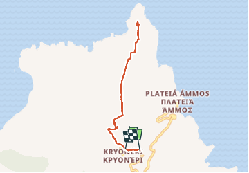
Trail Walking of 7.7 km to be discovered at Attica, Regional Unit of Islands, Municipal Unit of Kythira. This trail is proposed by LBarel.

Description

Un aller-retour de Kryoneri vers le phare de Moudari au nord de Cythère. Il existe de vrais chemins de randonnées que nous avons croisés régulièrement, mais ici il s'agit de routes non asphaltées larges et très praticables qui permettent de se concentrer sur le paysage plutôt que sur ses pieds. Très agréable balade.

Elevation profile

Photos

Positioning

Country:
Greece
Region :
Attica
Department/Province :
Regional Unit of Islands
Municipality :
Municipal Unit of Kythira
Location:
κ. Καραβά
Start:(UTM)
674672 ; 4025251 (34S) N.

Trails nearby

Trail On foot Municipal Unit of Kythira - M41 Mylopotamos Trail (long loop) - Photo
On foot
PRO

On foot

Easy
Municipal Unit of Kythira, Attica, Regional Unit of Islands, Greece
4 km | 5.9 km-effort
1h 20min
Yes


Close
My subscriptions